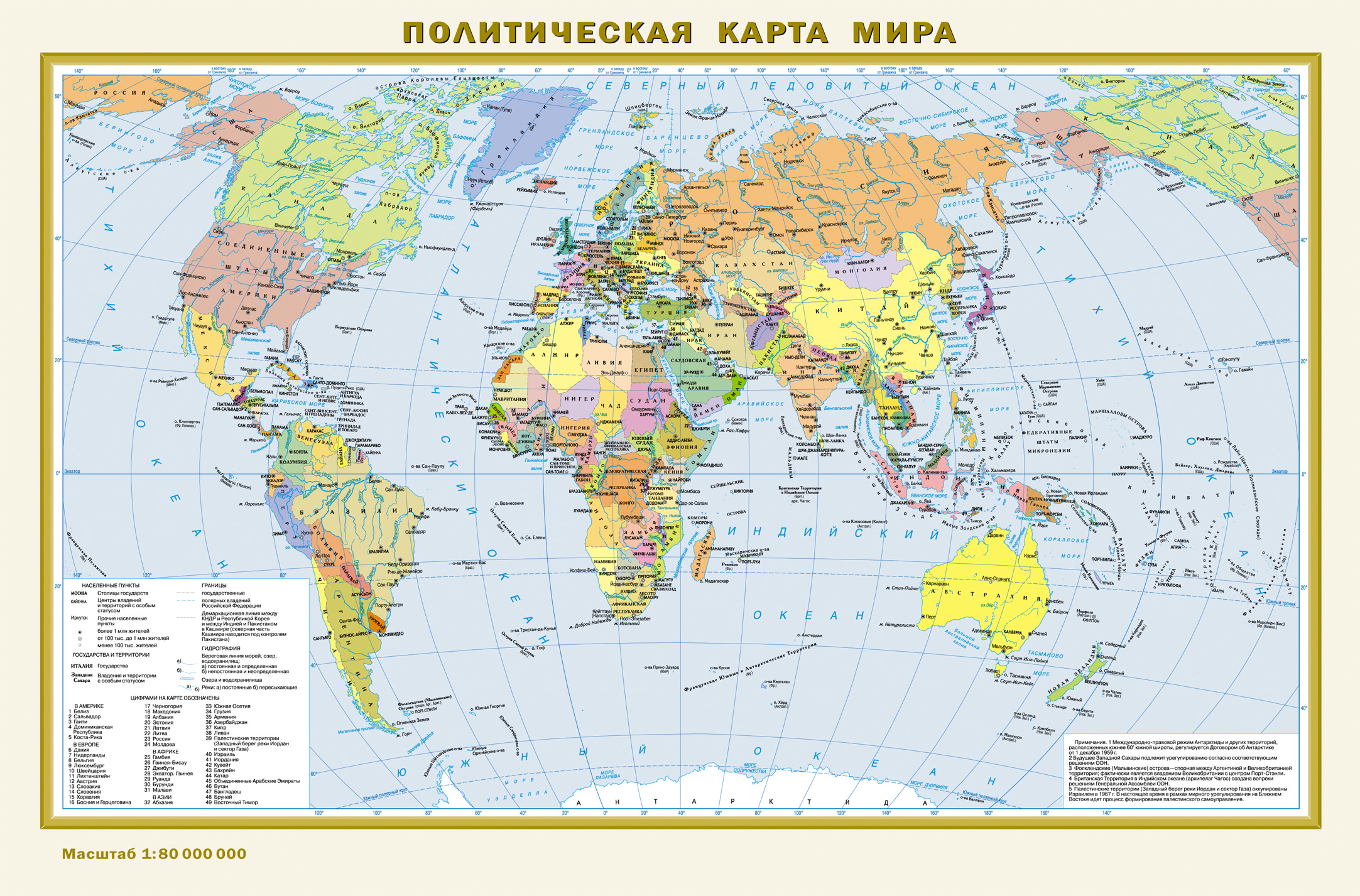
Эта карта формата А3 имеет размеры 440 мм х 290 мм и с обеих сторон покрыта полимерной плёнкой. На одной стороне листа - Физическая карта мира в масштабе 1:80 000 000 (в 1 см 800 км). Она демонстрирует распределение горного, равнинного и производных типов рельефа по поверхности суши Земли. Пунсонами с высотными отметками показаны высочайшие вершины всех континентов и основных горных систем. Даны все наиболее крупные реки с притоками и озёра. Представлен также рельеф дна Мирового океана с выделением хребтов, котловин и глубоководных желобов с их наибольшими глубинами. В океанах показаны тёплые и холодные течения. На обороте листа - Политическая карта мира того же масштаба. На ней показаны все независимые государства мира с их столицами, а также владения и территории с особым статусом. Населённые пункты на карте даны в трёх градациях численности: более 1 млн жителей, от 100 тыс. до 1 млн, менее 100 тыс. жителей. Рекомендовано для широкого круга пользователей. Масштаб 1 : 80 000 000.
Eta karta formata A3 imeet razmery 440 mm kh 290 mm i s obeikh storon pokryta polimernoy plyenkoy. Na odnoy storone lista - Fizicheskaya karta mira v masshtabe 1:80 000 000 (v 1 sm 800 km). Ona demonstriruet raspredelenie gornogo, ravninnogo i proizvodnykh tipov relefa po poverkhnosti sushi Zemli. Punsonami s vysotnymi otmetkami pokazany vysochayshie vershiny vsekh kontinentov i osnovnykh gornykh sistem. Dany vse naibolee krupnye reki s pritokami i ozyera. Predstavlen takzhe relef dna Mirovogo okeana s vydeleniem khrebtov, kotlovin i glubokovodnykh zhelobov s ikh naibolshimi glubinami. V okeanakh pokazany tyeplye i kholodnye techeniya. Na oborote lista - Politicheskaya karta mira togo zhe masshtaba. Na ney pokazany vse nezavisimye gosudarstva mira s ikh stolitsami, a takzhe vladeniya i territorii s osobym statusom. Naselyennye punkty na karte dany v tryekh gradatsiyakh chislennosti: bolee 1 mln zhiteley, ot 100 tys. do 1 mln, menee 100 tys. zhiteley. Rekomendovano dlya shirokogo kruga polzovateley. Masshtab 1 : 80 000 000.
This map A3 has dimensions 440х290 mm and coated on both sides with polymer film. On one side of the sheet - Physical world map in scale 1:80 000 000 (1 cm 800 km). It demonstrates the distribution of mountain, plain and derived types of the relief of the Earth's land surface. Punsonamy with spot elevations shown highest peaks of all continents and major mountain systems. Given all the major rivers with its tributaries and lakes. Also presents the bottom topography of the oceans, highlighting ridges, basins and deep-sea trenches with their greatest depths. In the oceans showing warm and cold currents. On the back of the sheet - Political world map of the same scale. It shows all the independent States of the world with their capitals, and possessions and territories with a special status. The settlements on the map are given in three grades of strength: over 1 million people from 100 thousand to 1 million less than 100 thousand inhabitants. Recommended for a wide range of users.Scale 1 : 80 000 000.