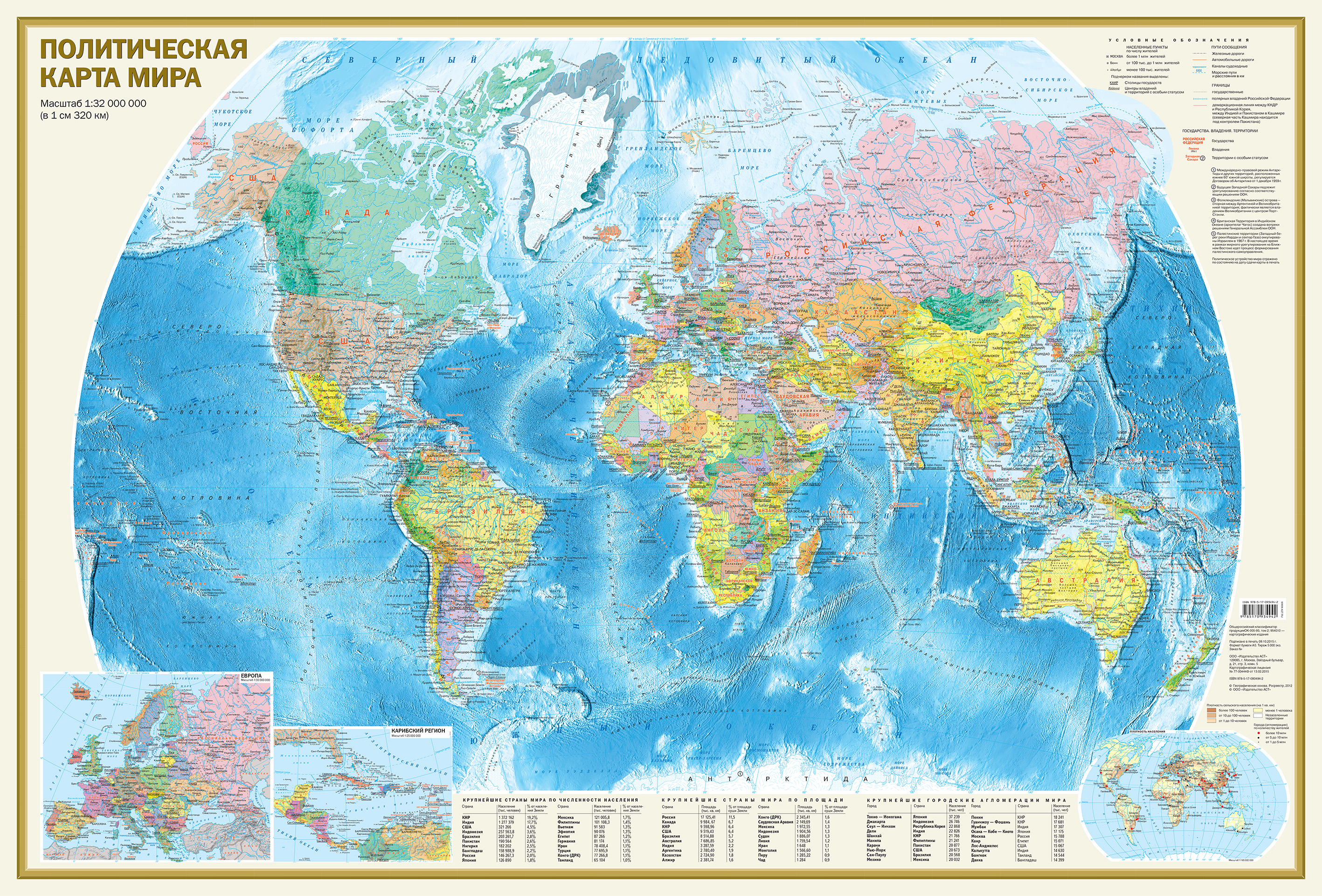
На Политической карте масштаба 1:32 000 000 (в 1 см 320 км) представлены все независимые государства мира, а также владения и территории с особым статусом. Хорошо различимыми пунсонами показаны населённые пункты с градациями «более 1 млн жителей», «от 100 тыс. до 1 млн жителей» и «менее 100 тыс. жителей». Отражены основные железнодорожные и автомобильные пути сообщения. Морские пути даны с указанием километража. Главную карту дополняют врезки в более крупных масштабах на Европу и Карибский регион, а также карта «Плотность населения». В табличном виде приведены данные о крупнейших странах мира по населению, площади, а также об основных городских агломерациях мира. Размеры карты 1170х790 мм.
Na Politicheskoy karte masshtaba 1:32 000 000 (v 1 sm 320 km) predstavleny vse nezavisimye gosudarstva mira, a takzhe vladeniya i territorii s osobym statusom. KHorosho razlichimymi punsonami pokazany naselyennye punkty s gradatsiyami bolee 1 mln zhiteley, ot 100 tys. do 1 mln zhiteley i menee 100 tys. zhiteley. Otrazheny osnovnye zheleznodorozhnye i avtomobilnye puti soobshcheniya. Morskie puti dany s ukazaniem kilometrazha. Glavnuyu kartu dopolnyayut vrezki v bolee krupnykh masshtabakh na Evropu i Karibskiy region, a takzhe karta Plotnost naseleniya. V tablichnom vide privedeny dannye o krupneyshikh stranakh mira po naseleniyu, ploshchadi, a takzhe ob osnovnykh gorodskikh aglomeratsiyakh mira. Razmery karty 1170kh790 mm.
On the Political map of scale 1:32 000 000 (1 cm to 320 km) presents all the independent States of the world, as well as possession and territory with a special status. Punsonamy are distinguishable settlements are shown with gradations of "more than 1 million people from 100 thousand to 1 million residents" and "less than 100 thousand inhabitants". Reflects the main rail and road routes. Sea route are given with the indication of mileage. The main map is supplemented with inserts on a larger scale in Europe and the Caribbean, as well as the map "population Density". In tabular form the data on the largest countries by population, area, and the major urban agglomerations of the world. The size of the card 1170х790 mm.